
In May 2026, water broke through the ground at Olkokwee, a settlement in Mogotio Constituency that sits nowhere near a riverbank. There had been no exceptional downpour to explain it.
The water simply surfaced, spread across more than 250 acres of farmland and stayed. Residents who had spent years watching Lake Bogoria advance from a distance suddenly found water rising beneath their own feet.
Mogotio MP Reuben Kiborek later told Parliament that “a new lake” was forming at Olkokwee. He called for geological surveys and early warning systems so people could be relocated before the ground gave way again.
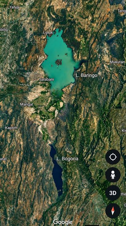
What is happening in Baringo County is no longer just a seasonal flood story. Two lakes that have existed as separate ecosystems for thousands of years, Lake Baringo and Lake Bogoria, are closing the distance between them. If they meet, freshwater will mix with alkaline water in a merger scientists say could be irreversible.
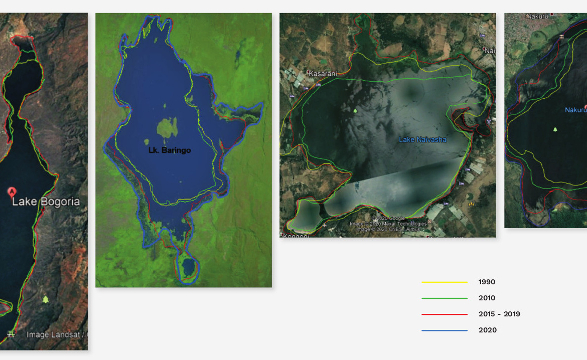
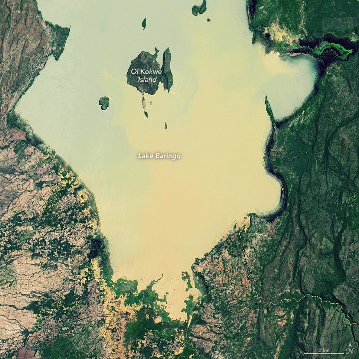
Lake Baringo and Lake Bogoria used to sit 20 kilometres apart. NASA’s Earth Observatory, tracking the lakes through Landsat satellite imagery since 2013, now puts the distance at roughly 13 kilometres. Neither lake has a natural outlet. Whatever rain and river water flows in has nowhere to go but up and outward.
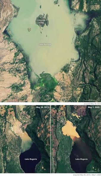
The scale of that rise is documented in government figures. Defence Principal Secretary Patrick Mariru told reporters in July that Lake Baringo’s water level has climbed by 12 to 14 metres over the past 15 years, adding an estimated 2 billion cubic metres of water to the lake. Separate reports put Baringo’s surface area growth at roughly 50 per cent over the same period, from about 160 square kilometres to more than 250.
“Lake Baringo and Lake Bogoria are on the verge of merging, if urgent interventions are not taken,” Mariru said. “It will cause an ecological disaster. One lake is salty, and the other is freshwater.”
Government estimates now place close to 380,000 people in the Baringo basin as either at risk or already affected by the swelling lakes.
The chemistry is the problem. Lake Baringo is freshwater and supports fishing communities and bird-watching tourism. Lake Bogoria is alkaline, and its hot springs, geysers and flamingo populations draw visitors from across the world. The two systems were never meant to touch.
Lydia Olaka, a research fellow at the Technical University of Kenya who studies environmental change in the region, explained that organisms in both lakes have adapted narrowly to their specific water chemistry.
“Bogoria and Baringo host specialised microflora and fauna that depend on specific water conditions,” she said. “Changes in salinity could disrupt these ecosystems and the larger species that rely on them.”
James Kimaru, senior warden at Lake Bogoria National Reserve, has already watched the reserve lose ground, literally. He said that the lake has swallowed nearly 20 square kilometres beyond its old boundaries, taking the park’s entry gate and access roads with it.
“Our entry gate, which used to be one of the best gates in this region, is now underwater,” Kimaru said. “There is a lot of infrastructure, the road from the main gate to the outpost, the Emsos gate towards Mogotio, most of it has submerged.“
For people living along the shoreline, the crisis is measured in relocations, not square kilometres.
Gladys Kurgat has moved his family three times since 2012 to escape the advancing waters of Lake Bogoria in southern Baringo County. The first move came in 2012. The second came eight years later, during the Covid-19 pandemic, when floodwater pushed the family further upstream. Today, they live in a tent on a neighbour’s property.
“We have nowhere to cultivate food crops and little pasture for our livestock,” Kurgat said. “We cannot produce food.”
Further along the lakeshore, longtime resident John Kibet has watched the water erase two generations of public infrastructure near his home.
“What Kenyatta built in 1976 is now under water. What Moi built in 1979 was also taken by the lake,” he said.
He said he now lives roughly 50 metres from the water’s edge and expects to be the next to move.
“If it rains again, we will have to move. We have no options left.”
Another Baringo resident, Paul Kiplagat, estimated that more than 600 households in his area have already been displaced.
“We had businesses here. We were farmers. But now we have nothing,” he said.
Displacement in Baringo has a history that predates the current crisis. In 2020, when Lake Baringo grew from 236 to roughly 278 square kilometres, more than 1,000 lakeshore homes went under. Ruth Cherono, a resident of Longewan village in Baringo South, observed that at the time that she had been displaced eight times since 2012.
“I am forced to become an internally displaced person every year,” she said.
Children have not been spared. At Loruk Primary School, pupils have had to wade through waist-high water on the Loruk-Chemolingot road to reach class, sharing the water with crocodiles and hippos.
The government’s current response centres on a large irrigation and diversion project meant to draw down Baringo’s water level while opening new farmland in the arid north.
Officials say the scheme, still in its feasibility stage, would eventually irrigate more than 100,000 acres, over three times the size of the Mwea Irrigation Scheme, currently Kenya’s largest public irrigation project. The stated goal is to ease flooding around the lake while creating agricultural jobs in Baringo and Turkana.
A separate proposal has come from Professor Simon Onywere, who has suggested diverting River Waseges into Lake Baringo rather than Bogoria, then channelling Baringo’s excess water toward the Suguta Valley for irrigation there. The idea is to turn floodwater into an asset instead of a threat, rather than simply pumping it away.
Neither plan has moved past the study phase. Kathiani MP Robert Mbui has pushed for something broader than an engineering fix, calling for a national strategy on climate displacement.
“I think this is what we are calling climate change,” he said, warning that repeated destruction of schools and roads was placing an unsustainable burden on local development budgets.
The data on how fast the lakes are closing in on each other comes from satellite imagery and government disclosures, and it is consistent across sources: a gap that was 20 kilometres has narrowed to about 13. What remains uncertain is the timeline.
No official source has published a projected date for when, or whether, the lakes will actually meet. The Olkokwee groundwater breach in May 2026 suggests the water is finding new paths to the surface that predictive models built on surface hydrology alone may not capture.

