Recurring floods along the River Nyando continue to devastate farms, infrastructure, and livelihoods, driven by land degradation, climate variability, and poor drainage in western Kenya.
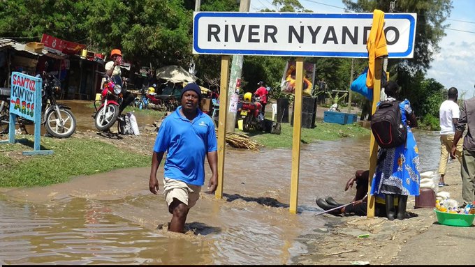
As floods once again disrupt lives across Ahero and the wider Kano Plains in March 2026, attention has turned to River Nyando, one of Kenya’s most flood-prone river systems. The latest overflows have cut off key transport routes, submerged farms, and displaced families, reinforcing a cycle that residents say has become all too familiar.
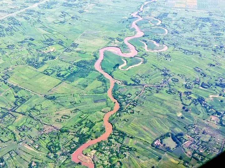
Originating from the Mau Escarpment and Nandi highlands at elevations of up to 3,000 metres above sea level, River Nyando travels roughly 150–170 kilometres before draining into the Winam Gulf of Lake Victoria, which sits at about 1,138 metres.
Along this journey, the river transitions from steep, fast-flowing upper catchments into the flat and low-lying Kano Plains, a shift that significantly slows water movement and increases the likelihood of flooding.
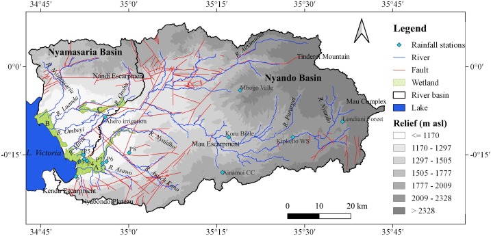
The Nyando River Basin spans approximately 3,450 to 3,600 square kilometres and supports an estimated 750,000 people, most of whom rely on climate-sensitive livelihoods. Across the basin, families depend on subsistence farming, livestock keeping, fishing, and small-scale trade.
In Ahero, rice farming dominates, particularly within the irrigation scheme, while crops such as sorghum, millet, and vegetables provide both food and income. Wetlands near the river’s mouth also support activities like papyrus harvesting, which sustains local craft industries.
Yet these livelihoods are highly exposed. The basin receives an average annual rainfall of about 1,360 millimetres, ranging from 1,000 mm near the lake to over 1,600 mm in the highlands, with temperatures averaging around 23°C. While rainfall follows a bimodal pattern, it has become increasingly erratic and intense in recent years, often overwhelming the river system.
Flooding along the River Nyando is not a new phenomenon. Historical records trace major flood events as far back as 1937, with significant episodes in 1947, 1957–58, 1961, 1985, and the devastating El Niño floods of 1997–98. The 2002–2003 floods escalated into a national emergency, drawing international attention and prompting early efforts toward flood management planning.
Scientific research, including findings from a ScienceDirect study on flood risk and vulnerability in the basin, shows that these floods are driven by a combination of environmental and human factors. Deforestation in the upper catchment, particularly within the Mau ecosystem, has reduced the land’s ability to absorb rainfall, sending large volumes of runoff downstream.
At the same time, soil erosion rates in parts of the basin are estimated at around 43 tonnes per hectare per year, contributing to heavy sediment loads that reduce the river’s capacity.
The Kano Plains further amplify the crisis. Their clay-rich “black cotton” soils limit water infiltration, while the flat terrain allows floodwaters to spread and stagnate over vast areas.
In some cases, rising levels of Lake Victoria push water back into the river, worsening flooding in downstream communities. On average, River Nyando discharges about 15 cubic metres of water per second, but flows vary sharply with the seasons, often becoming destructive during peak rainfall.
The March 2026 floods have once again exposed these vulnerabilities. Sections of the Ahero Bridge were submerged, disrupting movement and isolating communities, while warehouses and farms were inundated. For farmers, the losses are immediate and devastating.
“My losses are up to 11 sacks of rice, while my neighbour lost nearly 50,” said Nerea Adhiambo, a local farmer in Mawembe. “Since the rice has been waterlogged, we can only sell it at a loss, mostly as poultry feed.”
Floodwaters have also forced the closure of schools, including Ahero Girls, leaving students stranded and families struggling to find transport home. Similar impacts have been recorded in past years. In 2020, floods in the basin destroyed rice worth an estimated Sh800 million, wiping out incomes and deepening economic hardship.
Despite the damage, flooding presents a complex paradox. While floodwaters deposit nutrient-rich silt that can improve soil fertility, they also bring widespread destruction, destroying crops, spreading water-borne diseases, and displacing households.
Efforts to control flooding through dykes and other infrastructure have been implemented over the years, but many have failed or deteriorated due to poor maintenance and repeated breaching.
Beyond flooding, the basin faces broader environmental stress, as evidenced by organizations with initiatives of restoration.
About 60 percent of the area is affected by land degradation, driven by deforestation, overgrazing, and unsustainable farming practices. Water quality has declined, fish populations have reduced, and key ecosystems such as the Nyando Wetland, covering thousands of hectares, are under increasing pressure.
The situation reflects a deeper intersection of climate variability, environmental degradation, and socio-economic vulnerability. With population density in some parts of the basin exceeding 1,200 people per square kilometre and poverty levels remaining high, the capacity of communities to recover from repeated shocks is limited.
As climate pressures intensify, River Nyando continues to serve as a stark reminder that flooding is not just a natural event but a complex crisis shaped by human activity and environmental change.
Without sustained investment in watershed restoration, improved land management, and resilient infrastructure, the cycle of loss is likely to persist, leaving communities in the basin caught between survival and uncertainty.