
An emerging El Niño in the tropical Pacific Ocean is once again drawing global attention, with climate experts warning that the phenomenon could amplify extreme weather events and influence rainfall and temperature patterns across many regions of the world.
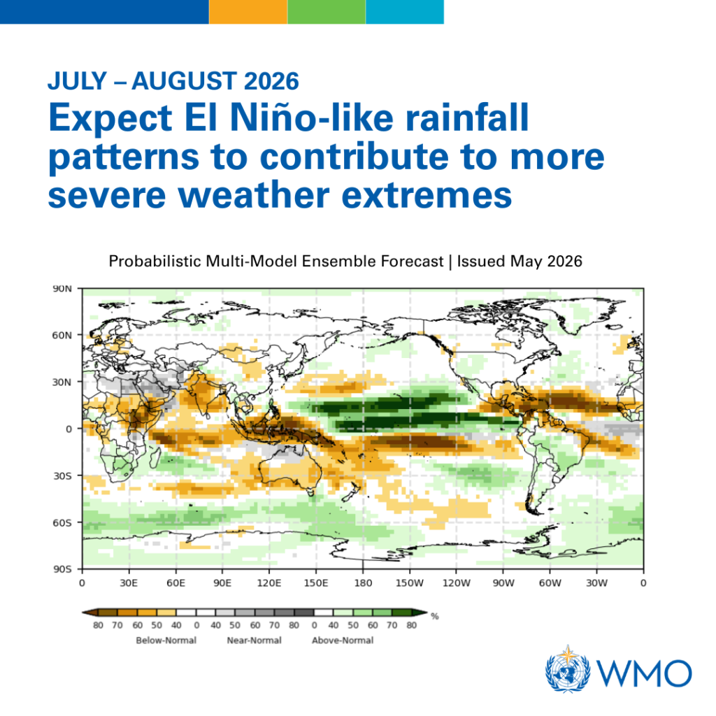
According to the World Meteorological Organization (WMO), there is an 80 percent probability that El Niño conditions will develop during the June–August 2026 period, with the likelihood rising to more than 90 percent through November.
While El Niño is a naturally occurring climate phenomenon, scientists warn that its impacts are unfolding in a world already warmed by human-induced climate change, increasing the risks associated with droughts, floods, heatwaves and other extreme weather events.
El Niño is one phase of the El Niño-Southern Oscillation (ENSO), a climate pattern driven by interactions between the atmosphere and ocean in the tropical Pacific.
It occurs when sea surface temperatures in the central and eastern equatorial Pacific become significantly warmer than average. These changes influence atmospheric circulation and can alter weather patterns thousands of kilometres away.
The UN Secretary-General António Guterres, in his video statement, pointed out that the only effective response is climate action equal to the crisis, ending the addiction to fossil fuels, accelerating the shift to renewables, protecting the most vulnerable, and delivering early warning systems for all.
“The science is clear: El Niño is arriving on our doorstep in the coming months with 90% certainty. The world must treat it as the urgent climate warning it is. El Niño conditions will pour fuel on the fire of a warming world. Impacts will hit even harder, travel even farther, and cross borders with devastating speed,” said Guterres.
A Climate Signal With Global Reach
The WMO says unusually warm subsurface waters in the tropical Pacific are currently feeding rising ocean temperatures at the surface, providing strong indications that El Niño is developing.
At the same time, atmospheric indicators such as the Southern Oscillation Index are also consistent with emerging El Niño conditions.
These signals matter because ENSO remains one of the most powerful drivers of seasonal climate variability worldwide.
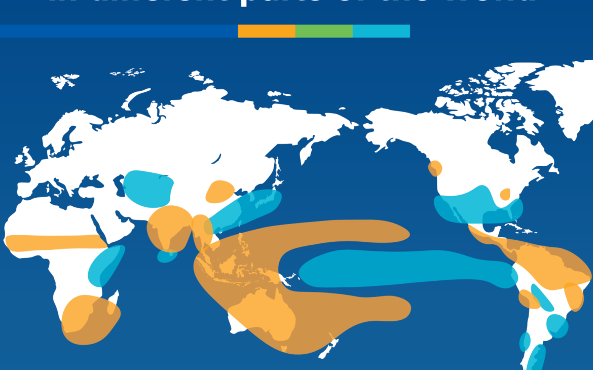
Historically, El Niño has been associated with increased rainfall in parts of the Horn of Africa, southern South America, and portions of the southern United States. Conversely, it often brings drier-than-normal conditions to Central America, Australia, Indonesia, parts of southern Asia, and northern South America.
The anticipated El Niño arrives just two years after the powerful 2023–2024 event, which contributed to record global temperatures and widespread climate extremes.
WMO Secretary-General Celeste Saulo has warned that a potentially strong El Niño could worsen droughts and heavy rainfall events while increasing the likelihood of marine and terrestrial heatwaves.
Although climate scientists have found no evidence that climate change increases the frequency of such events, a warmer atmosphere and ocean can intensify their consequences.
More moisture in the atmosphere means heavier rainfall when storms occur, while higher background temperatures can worsen heatwaves and accelerate drought conditions where rainfall is reduced.
In essence, El Niño acts on top of an already warming climate system. “The WMO community will be carefully monitoring conditions in the coming months to inform decision-making by governments, humanitarian agencies and climate-sensitive sectors. Advance seasonal forecasts and early warnings are vital to save lives and cushion the impact on our economies and our communities,” said Celeste Saulo.

Implications for the Greater Horn of Africa
For the Greater Horn of Africa, climate outlooks linked to the developing occurrences in weather suggest increased uncertainty in rainfall patterns.
The Greater Horn of Africa Climate Outlook Forum (GHACOF) projects a high likelihood of below-normal rainfall across much of the northern Greater Horn during the June–September rainy season.
Such conditions could affect crop production, pasture availability, and water resources, particularly in areas already vulnerable to climate shocks.
At the same time, some regions may experience episodes of heavy rainfall and flooding, underscoring the complexity of El Niño impacts and the importance of localized forecasts.
Experts stress that El Niño itself is not a disaster. Rather, it is a climate signal that helps governments, humanitarian agencies, and communities anticipate potential risks.
Seasonal forecasts, early warning systems, and preparedness measures can help reduce losses and protect lives and livelihoods.
As meteorological agencies continue to monitor developments in the Pacific, the focus is increasingly shifting from prediction to preparedness.
For communities already facing climate-related challenges, the message is clear: understanding El Niño today can help reduce its impacts tomorrow.

