The Kenya Meteorological Department has issued an early alert that El Niño conditions are likely to develop later this year and persist through the end of 2026, with the October-to-December season expected to bring significantly enhanced rainfall across the country. For millions of Kenyans living near rivers, on marginal farmlands, and in informal settlements, this is a countdown.
El Niño is a natural climate phenomenon that raises global temperatures for up to a year. It occurs when the easterly trade winds weaken, causing warmer waters to accumulate in the eastern equatorial Pacific, off the west coast of Chile, Peru, and Ecuador. El Niño events typically last nine to twelve months and occur every two to seven years.
The last El Niño was in 2023-2024. For East Africa, and Kenya in particular, El Niño’s signature is well known. When the Pacific warms, Kenya’s short rains intensify, rivers burst their banks, and the consequences ripple across health, agriculture, and livelihoods.
What makes 2026 different is the scale of what is forecast. As of May 2026, forecasts indicate a ‘strong’ to ‘very strong’ El Niño is likely. A ‘strong’ El Niño is defined as sea surface temperatures 1.5 to 2°C above average in a specific area of the Pacific Ocean, while a ‘very strong’ El Niño exceeds 2°C. Only three El Niño events have crossed the 2°C threshold since reliable records began.
The Climate Brink multi-model forecast currently gives a 70 to 84 percent chance of a ‘very strong’ El Niño for each of the three months from July to January, with sea surface temperature predictions peaking at 3.1°C above average in December.
Crucially, this event arrives on top of a world already significantly warmer than it was a century ago. The 2026-2027 El Niño comes on top of a world that is already about 1.4°C hotter than pre-industrial times due to climate change, increasing the possible sea and air temperatures El Niño can produce.
Some scientists project that 2027, when El Niño has fully developed, could reach temperatures as high as 1.61°C above pre-industrial levels, well above the current record of 1.55°C set in 2024.
Kenya’s meteorologists, too, are watching this closely. The Kenya Meteorological Department says it is closely monitoring the anticipated development of El Niño conditions in 2026 and notes that El Niño is often associated with enhanced rainfall during the October-to-December season across the country.
A separate warning from Kenya Met, shared through Citizen TV, raised the alert further. Over 80 percent probability of enhanced rains in that same season, with Tana River and Garissa counties specifically identified as likely to experience flooding.
County governments and humanitarian agencies are already preparing to reduce the impact on vulnerable communities. The department has pledged to continue updating the public as the situation develops.
Kenya has lived through this before. In 1997, exceptionally heavy rains associated with the El Niño phenomenon caused havoc in most parts of eastern Africa, with severe floods seriously affecting food production and distribution.
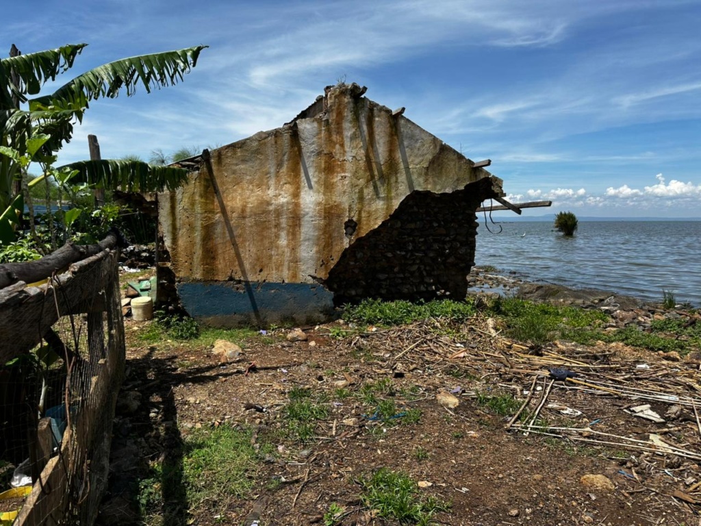
In Kenya, the loss of human life was significant. The 1997/1998 El Niño-induced floods caused an estimated US$151.4 million in public and private property damage, destroyed infrastructure, disrupted communication networks, and inflicted large losses on the economy.
Rains that fell 60 to 100 times heavier than normal in north-eastern Kenya triggered an outbreak of Rift Valley Fever, resulting in an estimated 89,000 human cases in north-eastern Kenya and southern Somalia, with between 200 and 250 deaths from that disease alone. Malaria also surged, with thousands of cases and at least 1,500 reported fatalities in north-eastern districts during early 1998. Roads, railways, and bridges were extensively damaged, isolating communities and hampering relief.
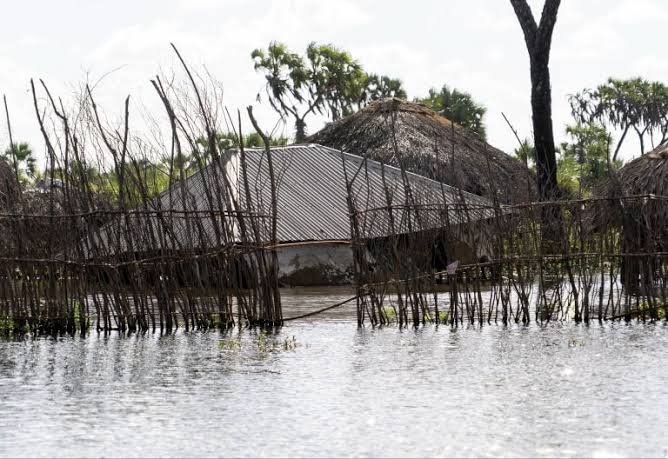
The 2023-2024 El Niño brought fresh devastation. From October 2023 to January 2024, El Niño-related flooding killed at least 174 people and displaced more than 500,000 households. More than 17,000 acres of farmland were destroyed, and over 13,400 livestock deaths were recorded. 38 of Kenya’s 47 counties were affected by a dangerous combination of riverine and flash floods, as well as landslides. Tana River and Garissa, the same counties now being flagged for the coming season, were among the hardest hit.
The pattern is not coincidental. El Niño increases the chances of extreme weather such as floods, droughts, wildfires, and heatwaves. However, climate change often plays a larger role, and in combination, they can lead to record-breaking extreme events.
Attribution science has increasingly confirmed this compounding effect. Some scientists believe climate change may also be affecting the frequency and intensity of El Niño events. Since the 1950s, there has been an increase in extreme El Niño events, and some researchers think the frequency of these extreme events could double if fossil fuel burning continues.
El Niño years bring particular patterns of heat, flood, and drought risk that lead to crop failures, increased wildfires, disrupted fisheries, increased conflict, and increased disease risk. The event can reduce life expectancy and cause economic losses that persist for years. For a country where a large share of the population depends on rain-fed agriculture and where health infrastructure in flood-prone counties remains stretched, these risks are not abstract.
Kenya Met’s early warning this June gives communities, county governments, and agencies roughly a three-month window to prepare. Preparations already underway, including the activation of early action protocols in high-risk counties, reflect lessons learned from 2023.